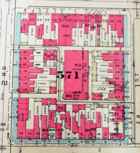
The CCNV shelter has its own chapter in the story of alley communities in Washington, D.C. The federal government constructed the building that currently houses the shelter during World War II. In the process, it destroyed what remained of a black working class alley community. On the block bounded by1st and 2nd and E and D NW, two alleys had existed prior to the building’s construction: Union Court and Baldwin’s Row. In the early twentieth century, there were fourteen homes on these two alleys. The block was hardly unusual, as it mirrored other downtown city blocks with significant alley communities.[1]

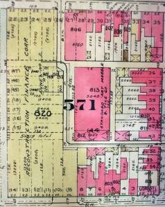
The demise of these two alleys also followed a typical pattern. In the early twentieth century commercial development and federal expansion destroyed many of these communities. The construction of the Standard Art Marble and Tile Co.’s warehouse after 1914 destroyed ten of the homes on Baldwin’s Row. A federally sponsored demolition project cleared the four remaining dwellings in 1940 to make way for the construction of a building that would house the Reconstruction Finance Corporation (RFC) – an agency that typified the expanding role of the federal government during the Great Depression and World War II.[2]

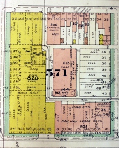
After the RFC was disbanded in 1957, the Securities Exchange moved into the building.[3] The structure was then turned over to Federal City College where it first opened its doors in 1968. The school consolidated with the DC Teachers College and Washington Technical Institute to become the University of the District of Columbia in 1977. It continued to use the building until it relocated to its new campus in Van Ness in 1980. The federally owned building stood vacant while an expanding housing crisis left more and more people sleeping on the adjacent downtown streets. Just as the alley residents of the early twentieth century found the central location desirable – within walking distance to many parts of the city – the homeless and homeless activists identified the site as an ideal place for a new model shelter.[4]

Currently, CCNV’s occupation of the building at 2nd and D NW is protected by a covenant with the federal government. But when the covenant expires in 2016, there is the potential for history to repeat itself on this block. Just as the black alley community inhabiting the spot was displaced, the shelter may be displaced for the sake of downtown commercial development or federal expansion. In considering the future of CCNV and the building at 2nd and D, it is important to remember the long-term claim to place by black working class communities that have existed downtown dating back to the alley dwellings of the 19th century.
[1] Sanborn map, v. 2, plate 152, block 571, 1914.
[2] Baist’s map, 1939, v.1, Plan 42, Block 571; Baist’s map, 1948, v.1, Plan 42, Block 571.
[3] Baist’s map, 1965, v.1, Plan 42, Block 571.
[4] U.S. House, Committee on Government Operations, Transfer Jurisdiction of Property for Homeless Shelter (H. Rpt. 99-616). Washington Government Printing Office, 1986.